
Spring Series 2019Coille NathaisSun 07 April, 2019
Local level event
Explanation of Event levels
Local events are usually low key and in the 'localised' area, ideal for newcomers to try the sport and Activities are non competitive events used for training and coaching, aimed at members of the club, but they can attract people from neighbouring clubs, and are often ideal for newcomers to try the sport. Regional events attract participants from around the local Region, National events are high quality competitions that will attract people from far away, Major events are Major Events such as a British Championships.
Results
Report
It's quite a while since EckO visited Coille Nathais but it was well worth it. Many thanks to Dave Bleazard and Leigh Murray for planning and organising the first of our Spring Series. We were short of numbers but those who did compete were treated to an extravaganza of orienteering experiences - navigation and route choice challenges, beautiful ancient woodland, runnable open moorland and the Bermuda Triangle of Coille Nathais.
Thank you also to Lorn Nelson for giving us permission to use the area and all our volunteer control collectors.
Location Info

Near: Taynuilt Lat,Lng: 56.4379,-5.2836
Open an interactive map in:
GoogleMap -
Streetmap (OS 50k)
OpenStreetMap -
BingMap (OS 50k)
Directions / Parking
The event will be signposted from the A85 1km NW of Taynuilt. Follow the minor road under the railway for 400m. Parking is limited; so please car share where possible.
Map / Terrain
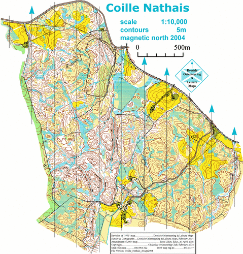
Between Connel and Taynuilt, Coille Nathais is partly open, rough moorland and partly deciduous woodland. There is a lot of contour detail, some steep slopes, and very few paths. The map is copyright Clydeside Orienteers.
Registration and Start times
Registration: From 10.30 am
Start times: 11.00 to 12.00
Courses close: 1.30
Course Information
Yellow : 2.1 km; straightforward navigation, some legs are marked with tape; no compass necessary.
Orange : 2.1 km; ability to use a compass is desirable.
Light Green : 4 km; more challenging (a compass is essential); most controls are not too far away from line features such as paths, fences, or streams.
Green : 5 km; full orienteering skills required (TD5).
Blue : 6 km: full orienteering skills required (TD5), but longer.
Entry Details
Juniors: £3
Seniors: £5 (members), £6 non-members
For this event maps must be printed on Tuesday (2nd April) evening. So, to ensure a map, it's best that you order your requirement(s) via info@ecko.org.uk before then. We always print extra maps, but these will be available on a "first-come-first-served basis" on the day. Please pre-order to avoid disappointment.
Dog restrictions
Dogs must be kept on a lead. And please pick up poo.
Facilities
None. Nearest villages are Taynuilt and Connel.
Contacts / Officials
Organiser: Dave Bleazard
Planners: Dave Bleazard, Leigh Murray
Email: info@ecko.org.uk